
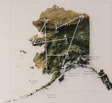
On Justin Posey’s treasure map there are numerous rivers and mountain peaks noted on the map of Alaska. More than any other state. Is there a clue on this portion of the map? I think so!
You’ll find the complete list of labeled areas below, but there are 9 mountain peaks with elevations.
Going from lowest to highest – and not counting Mt. Denali – because all states had the highest peaks shown on the map – (EXCEPT one – This may be another clue with meaning yet to discern. More on that another time!)
But going from lowest to highest – is 42. Clearly seen.

There are other possible 42 clues. These seem to be adding up! The question is why? Join discussions on the MW Discord – maybe we can figure out why together.
Locations listed on Alaska Portion: (Locations listed on Main Land Map)
- Juneau – State Capital
- Mt. Denali – Highest Peak (20,194 ft)
- Denali National Park
- Mt Marcus Baker (13176 ft)
- Redoubt Volcano (10, 197 ft)
- Mt Chamberlain (8901 ft)
- Mt Oyukak (6909 ft)
- Mt Tozi (5360 ft)
- Mt Osborn (4714 ft)
- Mt Siniatanneyenak (4524ft)
- Mt. Crooked (4329 ft)
- Glacier Bay National Park
- Kenai Fjords National Park
- Wrangell-St. Elias National Park
- Meade River
- Colville River
- Porcupine River
- Yukon River (labeled twice)
- Noatak River
- Kobuk River
- Koyukuk River
- Tanana River
- Copper River
- Kuskokwim River
- Mulchatna River
- St. Lawrence Island
- Nunivak Island
- Kodiak Island
- Seward Pennisula
- Pacific Ocean
- Bering Sea
- Alaska Range (mountain range)
- Brooks Range (mountain range)
- Artic Coastal Plain